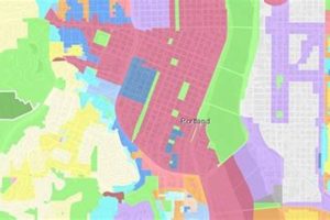
Land use regulations in the city of Portland, Oregon, dictate how property can be developed and utilized. These regulations classify areas into distinct zones, each specifying permitted building types, density limits, and other development standards. For example, a residential zone might allow single-family homes, while a commercial zone permits retail businesses and offices.
These regulations are crucial for shaping the city’s physical form, influencing housing affordability, promoting economic development, and protecting environmental resources. Historically, Portland’s planning policies have evolved to address issues such as urban sprawl, transportation efficiency, and equitable access to housing and amenities, reflecting changing societal priorities and community needs.
The subsequent sections will delve into specific aspects of these regulations, including residential zones, commercial zones, mixed-use zones, and overlay zones. Furthermore, it will explore the processes involved in obtaining permits, variances, and navigating the regulatory framework for property development and renovation.
Understanding and complying with the city’s planning and zoning codes is essential for successful property development and management. The following tips offer guidance on key aspects of navigating these regulations.
Tip 1: Comprehensive Research is Paramount. Prior to any property purchase or development plan, conduct thorough research of the specific zoning designation. Consult the city’s official zoning maps and code documents to identify permitted uses, density restrictions, and other applicable regulations.
Tip 2: Engage with City Planning Staff. Schedule a pre-application conference with city planning staff. These meetings provide an opportunity to discuss proposed projects, clarify regulatory requirements, and identify potential challenges early in the process.
Tip 3: Understand Overlay Zones and Their Implications. Be aware of the presence of overlay zones, such as historic districts or environmental conservation areas. These overlays impose additional restrictions and design requirements that must be considered.
Tip 4: Master the Permitting Process. Familiarize yourself with the permitting process for various types of development projects. Understand the required documentation, review timelines, and opportunities for public input.
Tip 5: Consider Variances and Appeals. If a proposed project does not fully comply with zoning regulations, explore the possibility of obtaining a variance or appealing a decision. Be prepared to demonstrate hardship and justify the need for deviation from the code.
Tip 6: Stay Informed on Code Updates. The city’s planning and zoning codes are subject to periodic updates and revisions. Stay informed of any changes that may impact your property or development plans.
Compliance with land use regulations contributes to responsible urban development, protects property values, and ensures the city’s livability. Proper attention to these codes is crucial for all property owners and developers.
The subsequent sections will provide a more in-depth analysis of specific zoning districts and development standards, offering practical guidance for navigating the intricacies of the system.
1. Residential Density
Residential density, a key element within the city’s land use framework, significantly shapes housing availability, neighborhood character, and infrastructure demands. The regulations governing residential density directly influence the types of housing that can be built and the number of people who can reside in a given area, impacting affordability and community composition.
- Zoning Code Designations
The regulations define specific zoning designations that dictate allowable dwelling unit densities. For example, an R5 zone may permit five dwelling units per acre, primarily accommodating single-family homes. Conversely, an RX zone might allow for higher densities, supporting multi-family buildings and apartments. These designations guide development and influence the mix of housing types within a neighborhood.
- Minimum and Maximum Density Requirements
Some zones impose minimum density requirements to encourage efficient land use and promote housing supply. Conversely, maximum density limits are set to manage population growth, preserve neighborhood character, and mitigate potential impacts on infrastructure such as traffic and utilities. Understanding these density parameters is crucial for developers and property owners.
- Incentive Programs and Density Bonuses
The city may offer incentive programs or density bonuses to encourage the development of affordable housing or the inclusion of specific amenities. These programs allow developers to exceed base density limits if they meet certain criteria, such as providing below-market-rate units or incorporating sustainable design features. Such incentives play a significant role in achieving broader planning objectives.
- Impacts on Housing Affordability
Density regulations directly impact housing affordability. Restrictions on density can limit the supply of housing, driving up prices. Conversely, allowing higher densities, especially near transit corridors and employment centers, can increase the supply of housing and potentially moderate price increases. Policies affecting density are thus central to addressing housing affordability challenges.
These facets of residential density, when viewed through the lens of municipal regulations, underscore the complex interplay between land use policy, housing markets, and community development. The city’s choices about density have profound and lasting implications for the city’s residents and its future.
2. Commercial Corridors
Commercial corridors, defined by the city’s planning code, are linear concentrations of commercial activity along major streets, playing a pivotal role in the economic vitality and urban form of Portland. These corridors are strategically designated to foster business development, enhance accessibility, and promote efficient land use, all within the framework of municipal zoning regulations.
- Zoning Designations and Permitted Uses
The city’s zoning code designates specific zones along these corridors, typically commercial (e.g., CM, CS) or mixed-use zones. These zones specify permitted uses, ranging from retail stores and restaurants to offices and service businesses. Zoning regulations dictate building setbacks, height limits, and parking requirements, shaping the physical characteristics of these commercial areas. Zoning decisions influence the type and scale of businesses that can operate within these corridors.
- Transportation and Accessibility Considerations
A critical aspect of commercial corridor planning involves integrating transportation and accessibility considerations. Zoning regulations often prioritize pedestrian-friendly design, encouraging sidewalks, street trees, and building frontages that enhance the walking environment. The city may also encourage transit-oriented development (TOD) along commercial corridors, aligning zoning with transit investments to promote efficient transportation options. Regulations thus ensure that these corridors are accessible by various modes of transportation.
- Design Standards and Urban Form
The planning code incorporates design standards that shape the urban form of commercial corridors. These standards address building aesthetics, signage, and landscaping, aiming to create visually appealing and cohesive commercial environments. Regulations may also require ground-floor retail or active uses to maintain pedestrian interest and vitality. Design standards, therefore, contribute to the overall character and appeal of these corridors.
- Economic Development and Job Creation
Strategic zoning of commercial corridors is intended to promote economic development and job creation. By concentrating commercial activity in designated areas, the city aims to attract investment, support local businesses, and generate employment opportunities. Regulations can also be tailored to encourage specific types of businesses, such as those that align with community goals or provide essential services. The city’s zoning framework actively shapes the economic landscape of these critical areas.
The comprehensive planning of commercial corridors, as dictated by municipal regulation, reflects a commitment to balancing economic development with community needs and urban design principles. The city’s approach seeks to create vibrant, accessible, and economically thriving commercial areas that contribute to the overall quality of life for its residents.
3. Mixed-Use Development
Mixed-use development, an increasingly prominent feature of urban planning, is closely interwoven with the framework of regulations in the city. This approach combines residential, commercial, and often civic or recreational uses within a single building or development project, fostering walkable neighborhoods and reducing reliance on automobiles. Zoning plays a critical role in enabling and shaping these developments.
- Zoning Designations and Permitted Combinations
The regulations define specific mixed-use zoning designations (e.g., CM1, CM2, CM3) that delineate the allowable combinations of residential, commercial, and other uses. These designations prescribe the percentage of floor area that can be allocated to each type of use, influencing the overall character of the development. For example, a CM2 zone may permit a greater proportion of residential uses than a CM1 zone. These choices shape the variety of urban spaces.
- Density Bonuses and Incentives
To encourage mixed-use projects, the city may offer density bonuses or other incentives to developers who incorporate desired elements, such as affordable housing, public plazas, or sustainable design features. These incentives allow developers to exceed base density limits in exchange for providing community benefits, promoting the creation of more vibrant and livable neighborhoods.
- Design Standards and Urban Form
The regulations include design standards that address the physical characteristics of mixed-use developments, including building height, setbacks, and facade treatments. These standards aim to ensure that mixed-use projects are compatible with the surrounding neighborhood context and contribute to a pedestrian-friendly environment. They often encourage ground-floor retail or active uses to maintain street-level vitality.
- Parking Requirements and Transportation Demand Management
Given the goal of reducing reliance on automobiles, the regulations often incorporate reduced parking requirements for mixed-use developments, particularly those located near transit corridors. The city may also require developers to implement transportation demand management (TDM) strategies, such as providing bicycle parking, transit passes, or car-sharing programs, to further encourage alternative modes of transportation.
The regulatory landscape, therefore, actively promotes the creation of vibrant, walkable, and economically diverse neighborhoods. Through carefully crafted zoning designations, incentives, design standards, and transportation policies, the city seeks to harness the potential of mixed-use development to create a more sustainable and livable urban environment. These planning decisions reflect a commitment to balancing economic development with community needs and environmental considerations.
4. Environmental Overlays
Environmental overlays, as integral components of zoning, serve to protect sensitive environmental resources within the city’s jurisdiction. These overlays function by imposing additional regulations on development within designated areas, layering over existing base zoning districts. This approach allows for a nuanced application of environmental protections, tailored to the specific characteristics of each resource. For instance, areas containing wetlands, steep slopes, or riparian corridors are often subject to environmental overlays that restrict building density, mandate buffer zones, and require erosion control measures. The implementation of these overlays is directly tied to the city’s Comprehensive Plan and other policy documents that outline environmental protection goals.
The effectiveness of environmental overlays depends on the precision with which they are mapped and the clarity of the regulations they impose. In practice, this means detailed surveys to identify sensitive areas and clear guidelines on permitted uses, development standards, and mitigation requirements. An example of an environmental overlay in action is the Willamette River Greenway, where development is carefully managed to protect water quality, maintain scenic views, and provide public access. Another example is the regulation of development on hillsides prone to landslides, which often involves restrictions on grading and vegetation removal. The practical significance of these overlays is evident in the preservation of natural habitats, the reduction of stormwater runoff, and the prevention of environmental damage that could result from unconstrained development.
In summary, environmental overlays represent a crucial mechanism for integrating environmental protection into planning processes. Their effective application presents ongoing challenges, including balancing the need for environmental protection with the rights of property owners and the demands of urban development. Despite these challenges, environmental overlays remain an indispensable tool for preserving the city’s natural heritage and ensuring a sustainable future.
5. Permitting Process
The permitting process is the formal mechanism through which the city ensures that proposed development projects adhere to regulations. Compliance with this process is mandatory for nearly all construction, renovation, and land use changes, and its effective navigation is paramount for property owners and developers seeking to realize their projects within legal parameters.
- Zoning Review and Compliance
The initial stage involves a comprehensive review of the proposed project’s compliance with zoning regulations. This assessment verifies that the project’s intended use, building dimensions, setbacks, and density align with the zoning designation for the property. Discrepancies identified during this review may necessitate project modifications or the pursuit of variances.
- Building Codes and Safety Standards
The permitting process includes a rigorous evaluation of the project’s adherence to building codes and safety standards. This entails submitting detailed architectural and engineering plans that demonstrate compliance with structural, electrical, plumbing, and fire safety requirements. Inspections are conducted throughout the construction phase to ensure ongoing adherence to these standards.
- Environmental and Historic Preservation
Projects located within environmentally sensitive areas or historic districts are subject to additional layers of review during the permitting process. These reviews assess potential impacts on natural resources, historic structures, and neighborhood character. Mitigation measures may be required to minimize any adverse effects, reflecting the city’s commitment to preservation.
- Public Notice and Community Input
Certain projects, particularly those that deviate significantly from existing zoning regulations or have the potential to impact surrounding properties, require public notice and opportunities for community input. This process involves notifying nearby property owners, holding public hearings, and soliciting feedback from neighborhood associations. Public comments are considered in the final permitting decision, fostering transparency and community engagement.
The permitting process, therefore, serves as a critical gatekeeper, ensuring that all development activities align with established zoning regulations, building codes, and community values. The successful navigation of this process necessitates thorough preparation, meticulous documentation, and a clear understanding of the applicable rules and procedures.
Frequently Asked Questions
The following addresses common inquiries regarding land use regulations within the city.
Question 1: What is the purpose of zoning?
Zoning regulations aim to manage land use and development within the city. They designate specific areas for particular uses, such as residential, commercial, or industrial, and establish standards for building size, height, and density. The goal is to promote orderly development, protect property values, and ensure public health and safety.
Question 2: How does one determine the zoning designation of a specific property?
The zoning designation of a property can be determined by consulting the city’s official zoning maps, accessible through the city’s Bureau of Planning and Sustainability. These maps delineate zoning districts and are often searchable by address.
Question 3: What are the potential consequences of violating zoning regulations?
Violations of zoning regulations can result in various penalties, including fines, stop-work orders, and legal action. The city may require the property owner to correct the violation, which could involve demolishing structures or ceasing unpermitted activities.
Question 4: Is it possible to obtain a variance from zoning regulations?
A variance may be granted if strict application of zoning regulations would result in undue hardship for the property owner. To obtain a variance, the property owner must demonstrate that the hardship is unique to the property and not self-imposed. The variance must also be consistent with the overall intent of the zoning code.
Question 5: How often are zoning regulations updated or amended?
Zoning regulations are subject to periodic updates and amendments to reflect changing community needs, planning priorities, and legal requirements. The city undertakes comprehensive zoning code revisions every few years, as well as more frequent targeted amendments.
Question 6: What role does community input play in zoning decisions?
Community input is a significant component of zoning decisions. The city provides opportunities for public participation through public hearings, neighborhood meetings, and online forums. Community feedback is considered when making decisions about zoning changes, specific development projects, and broader planning policies.
These FAQs offer a foundational understanding of regulations. Consulting directly with the Bureau of Planning and Sustainability is advisable for specific inquiries.
The subsequent sections will delve into resources available to navigate regulations effectively.
Portland Oregon Zoning
This exploration has outlined the multifaceted nature of regulations, encompassing residential density, commercial corridors, mixed-use development, environmental overlays, and the permitting process. These elements collectively shape the built environment and influence the city’s economic, social, and environmental well-being.
The effective implementation and ongoing evaluation of regulations are crucial for ensuring that the city evolves in a manner that is both sustainable and equitable. Continued engagement from stakeholders, including property owners, developers, and community members, is essential for navigating the challenges and opportunities that lie ahead, fostering a prosperous and livable urban landscape.


